Overview
Encircling higher ground beyond the earlier Santa Margherita (Firenzuola) Lines, the Cottonera Lines form the outer belt of a two-ring defensive system protecting the Grand Harbour settlements. They are closely associated with the grand urban-fortress concept of Civitas Cotonera—a fortified area intended to shelter tens of thousands of people in wartime.
Key dates & history
A practical timeline that matches what you’ll see on the ground.
What you’re looking at: the “outer belt” logic
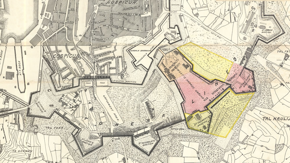
The Cottonera Lines are classic bastioned fortifications: projecting bastions and demi-bastions connected by curtain walls, designed so defenders could cover the base of neighbouring walls with overlapping fire. The earlier Santa Margherita Lines sit inside this ring, creating a layered defensive system around the Three Cities and the dockyard approaches.
Key features to look for
- Long bastioned perimeter: the scale is the story—seek viewpoints where walls “run” across the landscape.
- Gates in strategic curtains: monumental portals were both access control and signalling/communication points.
- Retrenchments and internal forts: later strengthening (like Fort San Salvatore) adds “defence within defence.”
- Unfinished intentions: in places you can sense where ditches/outworks were planned but not fully executed.
Best places to visit around the Cottonera Lines
These stops focus on the most visitor-friendly sections: major gates, legible bastion geometry, and viewpoints that show the perimeter’s extraordinary length.
1) Notre Dame Gate (Bieb is-Sultan / Żabbar Gate)
The best single “anchor” visit: a baroque gate complex completed in 1675 and long used for access and communications. Today it’s strongly associated with heritage activity and is one of the easiest places to understand how the Lines controlled movement.
2) San Salvatore Bastion sector (and Fort San Salvatore area)
A powerful bastion zone where you can appreciate the thickness of the ramparts and the way later fort-building reinforced the line. Look for the “retrenchment” idea—an internal strongpoint if the outer wall were ever breached.
3) Gate-hunting walk: surviving gates and blocked portals
Several Cottonera gates and historic portals survive (some open, some blocked). Even when a gate is no longer used, it often preserves the best architectural detailing and tells you where historic routes entered the fortified city-belt.
4) Viewpoints across the perimeter (e.g., Għajn Dwieli area)
Pick a viewpoint where the ramparts are visible in a long sweep—this is where the Cottonera Lines feel most “continental” in scale. Bring a wide lens: the best photos come from angles that show consecutive bastion faces and curtains.
5) Pair with the Three Cities (Birgu, Senglea, Cospicua)
The Lines make the most sense when paired with the urban cores they protected. Combine rampart views with waterfront walks and look back toward Valletta to understand the Grand Harbour fortification network as a single defensive system.
Suggested walking route (simple + high impact)
- Start at Notre Dame Gate (landward “front door” of the Lines).
- Follow visible ramparts toward a bastion sector where the geometry is clear.
- Detour to the San Salvatore area for the strongest “walls + internal fort” impression.
- Finish at a perimeter viewpoint to see the Lines running across the landscape.
- Add time for the Three Cities streets and waterfront (great contrast to the military architecture).
FAQ
Why are they also called the “Valperga Lines”?
The alternative name reflects the association with engineer Antonio Maurizio Valperga, linked to the broader design and planning of the Cottonera defensive scheme.
When were the Cottonera Lines built?
Planning intensifies in 1669, construction begins in August 1670, major phases stall around 1680, and the line reaches “completed” status in the 1760s (with some intended outworks never fully built).
Are the Cottonera Lines free to visit?
Many sections are visible and walkable from public roads and paths. Certain interiors (gate buildings or restored areas) may have specific opening times or access rules.