At a glance
- Role: Main island of the Maltese archipelago
- Known for: Megalithic temples, fortified cities, maritime history
- Language: Maltese (Semitic roots with Romance influence) and English
- Landscape: Limestone plateaus, harbours, cliffs, bays
How to use this guide
- Read Malta’s history in chronological sections below
- Use eMalta.com location pages to explore towns and sites
Geography and identity
Malta’s identity is inseparable from its geography: a strategically placed island in the central Mediterranean, defined by natural harbours, a rugged coastline, and limestone landscapes that made both fortification and stone-building a natural part of daily life for millennia.
Malta’s story is best understood as a sequence of “layers”: each era reused and reshaped what came before — roads, sacred sites, defensive lines, and even place-names.
Prehistory: the Temple Period and early society
Malta is internationally significant for its prehistoric remains, including some of the world’s oldest free-standing stone monuments. Early Neolithic settlers arrived by sea and established agricultural communities. Over centuries, they developed a complex ritual and architectural tradition that culminated in the Temple Period.
Megalithic temples and the ritual landscape
Sites such as Ħaġar Qim, Mnajdra, Tarxien and others reveal sophisticated stone engineering, planning, and symbolic culture. These places were not isolated buildings: they were part of a wider ritual landscape tied to seasonal cycles, community identity, and controlled access to sacred space.
Transition and continuity
Malta’s prehistoric record includes later Bronze Age phases that reoriented settlement and defensive choices, leaving traces across the island in smaller sites, tool traditions and field patterns.
Phoenicians and Carthaginians: Malta enters Mediterranean trade networks
By the first millennium BC, Malta became integrated into Phoenician maritime networks. The island functioned as a strategic stop and trading node, helping connect the central Mediterranean with wider routes.
Carthaginian influence followed, continuing Malta’s role as a maritime outpost with a mixed economy based on trade, seafaring and agriculture.
Roman Malta: towns, estates and early Christianity
Under Roman rule, Malta developed as a prosperous province with towns, villas and agricultural estates. Roman-era material culture and building practices contributed to a long tradition of urban settlement.
Malta is also strongly associated with early Christianity through long-standing traditions connected to St Paul’s shipwreck and the gradual Christianisation of the island across late antiquity.
Medieval Malta and Arab influence
Arab rule (from the late 9th century) profoundly shaped Malta’s language, agriculture and settlement patterns. The Maltese language retains a Semitic foundation with later influences, reflecting Malta’s layered history.
After the Norman reconquest, Malta became part of the Kingdom of Sicily. Medieval urban life reorganised around fortified centres, with Mdina and the surrounding district forming a political and administrative core.
The 1436 Bishop de Mello Rollo: Foundational Ecclesiastical Mapping
Commissioned by Bishop Senatore de Mello in 1436 to resolve administrative tax and tithe disputes among the cathedral canons, the historic document originally titled Quinterniolus pro Concordia Taxarum serves as the definitive foundational footprint of the late-medieval Maltese islands. Rather than establishing new entities, the Rollo officially recorded the twelve major existing parishes (cappelle) that were already fully functioning across Malta, alongside the centralized mother church of Gozo. This matrix provides an invaluable look at the ancestral boundaries of the islands before the subsequent fragmentation and expansion of modern town borders.
When reviewing Maltese parochial archives, researchers frequently encounter references to the "Ten Existing Parishes" of the 1436 Rollo. This specific historical figure refers strictly to the independent rural farming villages (the Casali) on the main island of Malta.
To understand the complete administrative reality of late-medieval Malta, historians look at the total allocation of twelve parochial operations across the island, plus the sister island of Gozo. The differences in historical tallies are categorized below:
- The Ten Rural Parishes: The standalone agricultural communities explicitly functioning outside the main fortified zones: Naxxar, Birkirkara, Qormi, Gudja (Bir Miftuħ), Żebbuġ, Siġġiewi, Żejtun (Santa Caterina), Żurrieq, Dingli (Ħal Tartani), and Mellieħa.
-
The Urban & Military Centers (Completing the 12):
- La Cattedrale di San Paolo (Mdina/Rabat): The ancient, fortified cathedral city which served as the seat of the Bishop and the mother church of the islands.
- San Lorenzo a Mare (Birgu): The thriving maritime harbor district centered around the garrison of the Castrum Maris (Fort St. Angelo), operating under a distinct naval administration.
- The Gozo Administration: Listed simply as "La Matrice" (The Matrix Church within the Gozo Citadel), this single entry confirms that Gozo operated under its own decentralized government board (the Università) and pooled all its regional countryside tithes into one secure fortress sanctuary.
| # | Medieval Parish Name (Cappella) | Modern Location Equivalent | Historic Medieval Boundary & Catchment Area |
|---|---|---|---|
| 1 | La Cattedrale di San Paolo | Mdina / Rabat | Served as the primary Cathedral Mother Church of the islands. Its localized parish operations ran out of San Paolo de Fora (St. Paul's Grotto) inside Rabat, covering both residential zones. |
| 2 | San Lorenzo a Mare | Birgu (Vittoriosa) | Managed the prominent maritime core of the Grand Harbor, the military garrison at the Castrum Maris (Fort St. Angelo), and the surrounding southern naval hamlets. |
| 3 | La Cappella di Santa Maria | Naxxar | A massive northern agricultural administrative hub. In 1436, its spiritual and fiscal boundaries encompassed the territories of Mosta, Għargħur, and Mellieħa. |
| 4 | La Cappella di Sant'Elena | Birkirkara | Controlled one of the most heavily populated inland agrarian districts, managing the farming estates across the vast central plains of the island. |
| 5 | La Cappella di San Giorgio | Qormi | Extended across the broad lowlands leading directly up to the inner marshes and valleys of the Grand Harbor basin (the modern Marsa, Floriana, and Valletta footprint). |
| 6 | La Cappella di San Filippo | Żebbuġ | Centered squarely on the thriving inland agricultural community of Casal Żebbuġ, managing dense rural fields and outlying estates. |
| 7 | La Cappella di San Nicola | Siġġiewi | Composed of a massive geographical footprint in the southwest, overseeing an intricate network of smaller, late-medieval troglodytic and farming hamlets. |
| 8 | La Cappella di Santa Maria | Gudja (Bir Miftuħ) | A massive southern mother territory. In 1436, this single parish held jurisdiction over the lands of Gudja, Kirkop, Għaxaq, Tarxien, Luqa, and Santa Luċija. |
| 9 | La Cappella di Santa Caterina (da la Parte di Scirocco) | Żejtun | Encompassed the entire southeastern coastal territory, managing the ancestral lands of Żabbar, Marsaxlokk, and Marsascala. |
| 10 | La Cappella di Santa Caterina (da la Parte di Libeccio) | Żurrieq | Covered the deep southwestern administrative boundary, managing the fields of Żurrieq, Safi, Mqabba, and the ancestral borderlines of modern-day Qrendi. |
| 11 | La Cappella di Santa Domenica | Dingli (Ħal Tartani) | A small, vulnerable cliffside parish. Following severe demographic declines due to corsair activity, it was later temporarily absorbed into Rabat before being re-established. |
| 12 | La Cappella di Santa Maria | Mellieħa | The northernmost frontier outpost. Due to relentless pirate incursions, its population fell so drastically that it was absorbed by Naxxar for centuries before its modern restoration. |
| — | La Matrice Church | The Citadel (Gozo) | The single centralized fiscal node for the island of Gozo. The Rollo acknowledged that all countryside chapels on the sister island fed their tax revenues directly into this fortress sanctuary. |
The Knights of St John: fortresses, cities and a new Malta
The arrival of the Order of St John (1530) was a turning point. The Knights transformed Malta into a major defensive stronghold, building fortifications, harbours and institutions that still define the island’s cultural landscape.
The Great Siege and the rise of Valletta
The Great Siege of 1565 became a defining event in Malta’s collective memory, followed by an ambitious rebuilding programme. Valletta emerged as a planned fortress-capital, designed for defence, administration, and symbolic authority.
Baroque Malta and parish life
From the 16th to 18th centuries, Malta’s parish system expanded and village centres were reshaped by church-building, feast culture, confraternities, and the craft economy supporting stonework, woodcarving and painting.
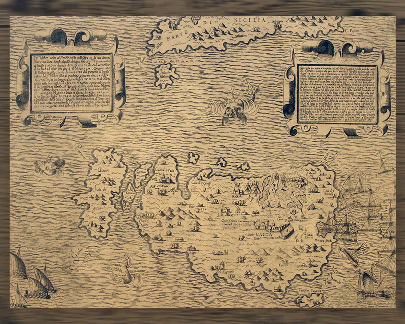
Domenico Zenoi’s Map of the Maltese islands
Domenico Zenoi’s Map of the Maltese islands, showing a scene from the Great Siege of 1565 when the Turkish fleet gathered off Marsaxlokk, seizes and holds our attention for all the interesting details it offers. The inverted positions of Comino and Cominotto and the Temple of Juno found on the island of Filfla are some of the inaccuracies characterising this map.
French episode and British period
French occupation (1798–1800) was brief but disruptive. After local resistance and the wider geopolitical context, Malta transitioned into the British sphere and became a strategically important naval base.
The British period (19th–20th centuries) introduced new administrative structures, education reforms, and infrastructure, while Malta’s harbours and dockyards shaped modern urban growth and labour history.
Modern Malta: independence, republic and contemporary identity
Malta’s modern era includes independence, state-building and a fast-changing economy. Tourism, services and heritage conservation are central, while local identity continues to express itself through language, festa culture, music, food, and neighbourhood life.
Modern Malta also grapples with the balance between development and preservation—especially in historic cores and coastal zones, where the pressure on land and heritage can be intense.
Why Malta matters
Malta is a microcosm of Mediterranean history: a small island with an outsized role in trade, defence, religion and cultural exchange. Its significance lies not only in monuments, but in continuity—how past and present remain visible in stone, language, and everyday life.